


It takes a vast network of infrastructure assets to make a morning cup of coffee. Wind turbines and gas pipelines provide energy. Power lines carry it to activate espresso machines. Trucks navigate the highways and bridges to deliver the coffee beans to the stores.
But society runs on more than coffee. Thousands of infrastructural assets support the steady flow of our daily lives, thus requiring inspections and maintenance to minimize wear and tear. Asset integrity inspection at scale is resource-heavy.
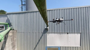
So drones enter the scene, augmenting human capability to cover greater distances, access remote areas, and obtain richer asset conditioning data without extensive prep work.
Learn how drone infrastructure inspection works and what are its advantages from this post.
How Are Drones Used in Infrastructure Inspection?
Drones help collect detailed, real-time data about asset conditions, especially in hard-to-reach areas. With drones, inspection of wind blades, bridges, or dams doesn’t require temporary asset shutdown, scaffolding construction, or rope access. Equipped with high-precision sensors and NDT probes, drones detect defects and material degradation early, allowing for preventative maintenance.
Here are a few examples where drone services bring the most value for infrastructure inspection:
- Bridge inspections: Drones easily fly over bridge decks, superstructures, and substructures, scanning for concrete cracks, spalling, and section loss. In metal bridges, drones with NDT probes can detect early signs of corrosion, welding flaws, and thinning of metal plates.
- Power line inspections. Drones reach high-altitude power transmission structures to check for visual damage and tower corrosion. Thermal cameras detect electrical leaks. You can also monitor right-of-way conditions for vegetation and fauna hazards or illegal construction sites.
- Pipeline inspections. Drones can oversee miles of pipes in one go — a benefit in remote mountainous, desert, or forested areas. Specialized drone payloads can locate leaks, cracks, corrosion, and insulation loss in hard-to-access components like pipe elbows and angled sections.
- Roadway inspections can be done quickly by drones without closing lanes. High-precision cameras detect pavement damage like cracking, crazing, and rutting. Autonomy allows automated monitoring of high-traffic, accident-prone areas.
- Wind turbine inspections. Drones can inspect rotating wind blades for cracks, delaminations, corrosion, or coating thinning. High-performance rotors allow them to withstand winds during inspections and an LPS probe determines if wind turbines are lightning-proof.
- Railway inspections. Drones scan miles of railway in a single operation, detecting broken rails, head checking, corrugations, indentations, and flaking. You can also monitor tracks for obstacles like fallen trees, abandoned vehicles, and power line collapses.
6 Advantages of Doing Infrastructure Inspection by Drone
Infrastructure reliability impacts every facet of life, from trade and public safety to education and recreation. Unnoticed defects can lead to collapses, environmental risks, and life-threatening situations.
Imagine the disruptions if Lake Pontchartrain Causeway, the world’s longest bridge over water carrying over 62,000 vehicles daily, stopped functioning. To avoid such scenarios,government agencies mandate routine inspections: weekly for railroads, bi-yearly for bridges, and every 5 years for pipelines and wind turbines.
Inspection drones help pass checks without causing a strain on people and budgets. In many cases, drones reduce inspection times for an asset by 4X and can potentially save up to $165k for a single inspection.
And the benefits don’t just end with cost and speed. Here are six more advantages of using drones for infrastructure inspection.
Richer, Real-Time Inspection Data
Visual inspection and non-destructive testing — modern inspection drones combine both. Top models include the latest visual sensors (e.g., CMOS) and optics for sharp images in low-light and dynamic environments.
In addition, many enterprise drones include extra payloads such as:
- Advanced imaging systems provide close-up, real-time streaming, and recording of surface-level damage. A wide-angle camera maps the asset’s surroundings. Some drones have great night vision — handy for scheduling work outside of operating hours.
- Radiometric thermal cameras measure the temperature of inspected objects, identifying leaks and changes in operating conditions.
- Ultrasonic and EMAT probes help identify surface and subsurface defects, including their size, shape, depth, and direction.
- Eddy-current probe locates subsurface defects and corrosion under insulation for conductive materials, even on inhomogeneous structures.
- LPS tester measures circuit resistance in wind turbine lightning protection systems.
Specialized payloads even allow working on high-temperature surfaces. Middough selected Voliro T fitted with an EMAT probe to inspect heated piping and collected up to 100 high-precision corrosion readings per hour, live displayed in the Voliro App. What’s more, Voliro managed to provide measurements even on hard-to-reach angled pipe segments.
International government agencies also confirm the high accuracy of drone inspections. The Minnesota Department of Transportation used UAVs to monitor the Arcola Bridge and captured detailed images of corroded parts without being too close to the structure. Meanwhile, Korean Railroad Research Institute (KRRI) uses AI-powered drones to inspect railway infrastructure and reports 90% precision in inspection camera images and 100 mm accuracy for defect location.